Author: Ada

Welcome to the Winter Wonderland

Things have changed a little since we last spoke. After a seemingly endless string of days in mid-40s, a week ago Thursday, just before midnight, it started to snow.

Cattails in the snow off the Gunflint Trail

And snow.

And snow.

By the time the weather system had passed us by on Saturday morning, we had almost 11″ of fluffy snow. By the time Monday morning rolled around there was a thin layer, about 1″, of ice completely covering Round Lake. Talk about Insta-winter!

Frozen Round Lake near the BWCAW on the Gunflint Trail

The thing is, the winter weather hasn’t let up since. On Tuesday and Wednesday, another 5″ of snow accumulated and all day today, fluffy (and un-forecasted) snowflakes drifted down lazily to earth to freshen up the already very wintery scene. As much as winter clobbered us with its arrival this year, after such a long fall, the change in season was very welcome.

Chickadee songbird at the bird feeders

We’re steadily marching towards the shortest day of the year, but there are plenty of sights in this new winter wonderland to keep us distracted from the fading daylight. The songbirds (and squirrels) are back at the feeders, each morning we find a new set of wolf tracks zigzagging through the resort, and the otters have been busy slipping and sliding across the beaver pond near the Gunflint Trail.

CrossRiver112516

Now that it actually looks like winter, it’s a little easier to thinking about things like winter camping and ice fishing. Dare we say, it’s beginning to look a lot like Christmas . . . ?

If you’re hoping to spend some of your holiday season at Tuscarora, you can check out cabin availability and give us a call at 218-388-2221 to book.  Because the Lodge will be closed for renovations over Christmas and New Year’s, we have limited availability over the holidays this year and the cabins we do have available are booking up fast. Consider yourself warned!

IMG_1158

As the snow accumulates outside we’re hunkering down, knuckling down on the Lodge bathroom renovation, and preparing for the busy holiday season ahead.

Not to add to the commercialism over this retail-centric weekend, but if you’re looking for Boundary Waters/Tuscarora presents for some of the paddlers on your gift list, look no further than the Gift Shop Mini-Mart we just launched on our website. You’ll find BWCA stocking stuffers like stickers and patches, as well as slightly larger items like coffee mugs for under the tree. Happy shopping and thanks for supporting small businesses!

The Frost is Not on the Punkin

They’s something kindo’ harty-like about the atmusfere
When the heat of summer’s over and the coolin’ fall is here—
Of course we miss the flowers, and the blossums on the trees,
And the mumble of the hummin’-birds and buzzin’ of the bees;
But the air’s so appetizin’; and the landscape through the haze
Of a crisp and sunny morning of the airly autumn days
Is a pictur’ that no painter has the colorin’ to mock—
When the frost is on the punkin and the fodder’s in the shock.
-James Whitcomb Riley

Everything Riley writes in “When the Frost is on the Punkin” is true these days at Tuscarora, except for the fact that there is no frost and there also aren’t any pumpkins. Also, I was stung by a wasp while planting tulip bulbs on Saturday and the begonias beside the outfitting steps are still going gangbusters, so I guess we’re in a strange, not quite summer, not quite autumn season at the moment.

That’s right, it’s October 3rd and we’ve yet to freeze on the Gunflint Trail. And what we’re lacking in pumpkins, we’re making up for in butternut squash. The squash plant must have received the perfect amount of rain and neglect this summer, because there are two beautiful large squashes hanging from the vines sprawled out on the lawn. (Mother Nature with her plentiful rainfall this summer sure helped out these inattentive gardeners.) We’ll wait until there’s a real threat of frost forming on their surfaces before we pick those squash and any of the other garden treasures.

Butternut Squash northern Minnesota gardening

In general, we usually figure the tomatoes have until September 20th to ripen. By the time we’re in the final third of September, we know a heavy frost will descend on the Gunflint Trail. On the evening of that frost, just as the sun is sinking on the western horizon, Andy and I will fill grocery bags with green tomatoes to ripen inside – our breath coming in misty clouds, our fingers growing increasingly numb as we pick.

But not this year. Our low temperatures this September were in the 40s and we didn’t even worry about a frost. Instead, Andy dutifully picked the tomatoes just as they started to turn red to keep the chipmunks from taking their customary single bite out of each reddish tomato and we made loads of BLTs and pico de gallo. When I was making supper, I’d say, “Hey Andy, can you get me a green pepper,” and instead of going to the fridge, he’d just go out the porch door and pick a green pepper from the large plant growing beside the tomatoes.

It’s weird.

It feels like we’ve won something. Or like we’re getting away with something. We’ve been slowly shutting down the seasonal buildings without even once worrying about pipes freezing. Everyone’s a little giddy about it all. To top things off, the fall colors are brilliant this year and they’re lingering.

Round Lake fall colors

How lucky are we? I mean, 70 degrees on October 1st? Yes please!

Round Lake Boundary Waters entry point October

To quote Laura Ingalls Wilder, there’s a deep sense that “now is now.”
Tuscarora Lodge flowers

Now is the time to take long rambles through the woods after work each day. Now is the time to eat garden produce fresh from the vine. Now is the time to just stop for a moment and soak in autumn sights and smells. After all, we might be just days, if not hours, from the first killing frost and the leaves tumbling to the forest floor.

Tuscarora Lodge in the autumn season

There’s no time for delayed gratification. Now. The time to revel in autumn is now! Now, before the frost is on the punkin and the fodder’s in the shock.

Ode to Autumn (Canoe Trips)

“So, how often do you get out for trips yourself?”

We’ve spent all summer answering that question and now the answer that we usually give is upon us: September.

September is when we go on canoe trips.

Of course, that’s not a hard fast rule. Like most folks, we go when we can. Sometimes that means June, sometimes we manage to sneak away at the peak of the season in late July or early August, but if we have our druthers, September is the month we choose for paddling trips.

Last autumn, Andy managed to get out for a trip with his buddy Andrew during the second full week of September. They did a six day/five night Quetico canoe trip via the Falls Chains, Kawnipi, Agnes, and McEwen Lakes.

Quetico Provincial Park Ontario Canada Paddle Trip It’s not the best photo documented canoe trip that ever was. Andrew’s camera broke on the second night they were out there.

(Here’s the last photo that camera ever took – Andrew with a walleye on the shores of Heronshaw.)

Quetico Provincial Park blue walleye catch

But the photos that they did get show just how beautiful an autumn canoe trip can be.

DSC03093 DSC03094 DSC03108 DSC03119
There are lots of reasons to opt for a late season canoe trip. With school back in session, the woods of the Boundary Waters and Quetico get pretty quiet. While there’s a little influx of visitors over each weekend in September, after Labor Day it’s not unheard of to go for days without seeing another soul, especially in Quetico. Traffic-free portages and the lack of campsite competition allow late season visitors to travel at their own pace. The days are noticeably shorter, which forces you to set up camp earlier and cool nights are infamous for good “sleeping weather.” The lakes start turning over, which means better lake trout fishing, if not poorer swimming conditions as the water temperature drops.

Of course, fewer people in the woods and colder temperatures mean late season campers need to be a little more vigilant about their personal safety. It’s especially important to have a good pair of rain gear along to keep you warm and dry during the inevitable September storms. Also, use a heavy duty pack liner to keep all your gear bone dry while you travel and embrace the lifejacket as your most important canoe trip fashion accessory.

If you’re hoping to get some fall colors in your late season canoe trip photos, be sure to check out the fall color updates that the Superior National Forest naturalist posts weekly. Although we’re starting to see some of the brushy undergrowth turn on the Centennial Trail hillside along the Round Lake Road, we’re still a ways out from true fall colors on the Gunflint Trail. A wet summer like the one we’ve just experienced usually coincides with lingering fall colors, but we’re not going to make any color predictions just yet.

While we can’t tell you when to time your trip for peak fall colors, here are a few things we can tell you definitely about planning an autumn Boundary Waters canoe trip:

  • If you want more daylight than nighttime on your trip: go before the autumnal equinox on September 22nd.
  • If you want to catch lake trout: go before the lake trout season closes on September 30th.
  • If you’d like to enjoy French toast the morning you start your trip: go before we close the kitchen on September 30th.
  • If you don’t want to pay for a Boundary Waters permit: go on or after October 1st, when all you need is a free, self-issuing Boundary Waters permit to camp overnight in the BWCAW.

A couple other autumn notes: our office hours are now 8 a.m. – 5 p.m. for the remainder of the 2016 season. We continue to serve breakfast at 7 a.m., so bunkhouse guests can still get an early start on the morning of their trip.

We hope to see you for an autumn canoe trip this fall.

What’s your favorite part of a late or early season canoe trip? 

Review: DeLorme InReach Wilderness Messaging Device

As the world becomes increasingly globalized and technology makes it easier and easier to stay in touch, we’re finding that more Boundary Waters visitors than ever want a way to get in touch with the outside world in case of emergency while in the wilderness or so they can keep up on any news from home. Tuscarora’s been offering satellite phones for a few years to help people with the somewhat incongruous goals of getting away from it all and still being reachable. For most people, having a satellite phone provides a sense of security for both themselves and their loved ones, the same way having a fully stocked first aid kit provides peace of mind on the trail. Like that first aid kit, a satellite phone’s meant to be just another tool in your pack in case the unthinkable happens.

But now that people have their phones on them almost every waking moment, sometimes people view a satellite phone as a clunky cell phone rather than an emergency device. This is when the three big “cons” of satellite phone usage pop up:

  1. Our satellite phone has a battery life of about 24 hours. This essentially makes the phone a call-out only device because it needs to be turned off for the majority of your trip to make sure it has enough “juice” to call in case of an emergency.
  2. You must be out in the open to get a signal for the phone. Satellite phones are notorious for dropped calls.
  3. Satellite phones are ‘spensive. Replacement costs are around $1300, so you really, really don’t want to accidentally drop it in the lake.

We figured there had to be a better way for people to do their canoe trips and still remain in contact.

Enter the DeLorme Inreach device.

DeLorme Inreach

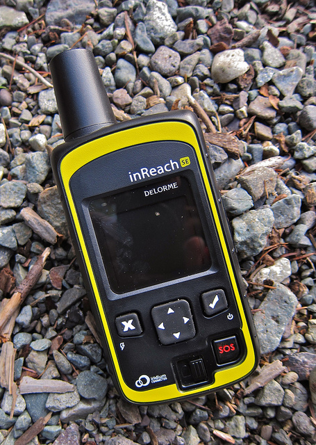
A longtime time Tuscarora guest has been talking up the DeLorme Inreach device for a while and this spring we decided to give it a whirl. It’s a bit of an apples to oranges comparison to compare the Inreach to a satellite phone, since you can’t make calls with the Inreach. Rather, the Inreach is a texting device that allows you to send text messages and emails (160 character limit per message) to people back home and have two-way conversations that way. There’s no monthly limit on messages that can be sent with our plan, so you don’t have to worry about racking up a big bill, no matter how much you use it during your travels.

The device also has an emergency SOS button that sends your location to emergency response and allows you to send a message describing the emergency. After the SOS button is pushed, it sends your location every 10 minutes to emergency response if you’re moving, or sends the location every 30 minutes if you’re stationery. Obviously, not a button you want to press accidentally, but handy to have, “just in case.”

Other things the Inreach can do:

  • Post your location on social media, including Facebook and Twitter.
  • Shoot waypoints on a map.
  • Uses a whole lot less battery than a satellite phone. You don’t want to leave it on during your entire trip, but you can use it freely without worrying about the battery dying.
  • Is water resistant and floats. Replacement costs are around $300.

A couple weeks back, Andy and his buddy Quinn decided to take advantage of this summer’s high water and paddle the Greenwood River about 30 miles southeast of Tuscarora. The Greenwood River not technically in the Boundary Waters, but it’s tucked away in some pretty remote reaches of the Superior National Forest. Arguably, you’re more likely to find assistance during an emergency when you’re in the Boundary Waters than in Greenwood country, since, more often than not, you’re on an established travel path while traveling in the BWCA. Down in Greenwood country, if you run into trouble, it’s going to be a long time before someone stumbles upon you.

Greenwood River

While no one really thought Andy and Quinn would find peril during their afternoon trip down the Greenwood, Andy threw in the Inreach to see how it would work in a wilderness situation.

When we were testing out the DeLorme around Tuscarora, we found that it can take a little while for the messages to transmit if you’re not out in the open. Also, if you’re moving while the Inreach is transmitting, it can get a little confused and might send duplicate messages. However, when Andy was down at Greenwood, we were able to go back and forth with just a minute or two lag time between messages.

When you open the link in the email or text sent with the Inreach, you’re brought to a map that pinpoints where the message was sent from. You reply to the Inreach sender right in the little message box on the righthand side of the screen.

image001

You can zoom in and out on the map to get a very specific location.

image001

Even if you didn’t want to message anyone during your trip, it would be kind of neat to send yourself your location so at the end of your trip you have several snapshots of your route.

All in all, we’ve found the Delorme Inreach to be a viable alternative to a satellite phone. You might not be able to send or receive very detailed messages with it, but it is a good way to check in at home with a simple, “all’s well,” and with its GPS tracking capability, it’s a useful tool if you have the misfortune of ending up at the center of a search and rescue mission. It’s a device that satisfies the map geek and provides peace of mind.

Currently we have one DeLorme in reach available for rental at Tuscarora and if it proves popular, we’ll make more available. If you try one out, be sure to let us know what you think.

Do You Know This Man?

IMG_2144

If you’re a fan of canoe country, you’ve probably stumbled across some photos of our buddy, Andrew. Last year, he served as the poster boy for the first annual Boundary Waters Canoe Expo. Over the years his photo has also appeared in numerous other advertisements for Visit Cook County and Tuscarora. You’ve also seen him in our post about 20-somethings going on canoe trips.

QueticoTuscLogoPhotoPin

But who is this man of mystery so often spied in the bow of a Souris River Quetico 17?

Andrew Quetico portage

Andrew, Andy, and I all worked together at Hungry Jack Outfitters back in the “Aughts.” He comes from “canoeing stock” – his mom worked on the Gunflint Trail as a young adult – and as a teenager, he did many canoe trips through Camp Menogyn, including a five week trip through the Canadian wilderness. Since our Hungry Jack days, the three of us have covered a lot of miles together, from roaming around Portland, OR to running Chicago’s Shamrock Shuffle this past spring (FYI: Andrew can run 8 km 14 minutes faster than I can), and, of course, he and Andy have gone on lots and lots of trips through Quetico Provincial Park.

Right now, Andrew is a biology PhD student at the University of Michigan where he focuses on the venom systems of mollusks. The end goal of his research is to create a way that the venom of mollusks can be used as human medicine, particularly as a side-effect free anesthesia. He spends a portion of each summer collecting cone snails for research from the bottom of the Pacific Ocean off Japanese or Samoan coasts.

Despite research that takes him around the world, back at the end of May, Andrew and his girlfriend, Clara, managed to carve out a week to spend in the Quetico. As you can see from the map below, they just did a teeny, tiny, little trip:

Andy and Andrew are known for their high mileage Quetico trips and Clara wanted to be sure that Andrew didn’t take it easy on her just because it was her first canoe trip. A quick gander at the map shows that Andrew did not let Clara’s lack of canoe trip experience impact the trip’s distance. In six days and five nights, they paddled 80+ miles. Oh, did I mention that Andrew and Clara had both run marathons two days before the start of their canoe trip? Obviously, these are not two people who are afraid of high mileage!

After a towboat ride from the Tuscarora dock on Saganaga Lake up to Hook Island on the Canadian side of Saganaga, Andrew and Clara paddled over to the Cache Bay Ranger Station to pick up their permit for the Man Chain. From Cache Bay, they headed up past Silver Falls, into Saganagons, and into the Man Chain which they followed down to Carp Lake and the International Border.

Quetico Loons Rafting

Loons rafting on This Man Lake

Quetico Canoe Portage landing

After paddling a few miles west on the border, they went over Prairie Portage and then cut back up into the Canadian interior via Sunday Bay in Basswood Lake. As they headed east back towards their starting point, they passed through Agnes, Louisa, McEwen, and Wet Lakes, before finally heading south via Saganagons and Cache Bay.

Andrew Quetico campsite
Quetico Tent View

Despite a wide variety of temperatures and weather that characterizes this spring, they had a great trip. In her first visit to Superior/Quetico country, Clara managed to see more of canoe country than some people see in years of BWCAW and Quetico canoe trips. A trip of this magnitude certainly isn’t for everyone, but these two, it worked just fine.

Quetico Portage
Clara Quetico

What’s the longest canoe trip you’ve ever done?