Like many, if not most, people who love the Boundary Waters Canoe Area Wilderness, we’re map people. To us, half the joy of BWCA canoe tripping is pouring over maps and weighing the merits of one route over another in the months leading up to the actual trip. Even if you’ve only gone on one Boundary Waters trip, chances are, you still have at least one map from that trip. The Boundary Waters and maps – they just go together.
For a long time, you had to make a binary choice about which map you wanted to use for Boundary Waters navigation: a Fisher or a McKenzie. We use these two companies’ maps interchangeably at Tuscarora, since the only real differences between the two are the scale and the background color. Back in 2007, Voyageur Maps joined the Boundary Waters map party, so it had been a good long while since there’d be anything new in the Boundary Waters map world. Suffice it to say, we were pretty excited when Hudson, Wisconsin based True North Map Company launched in January.
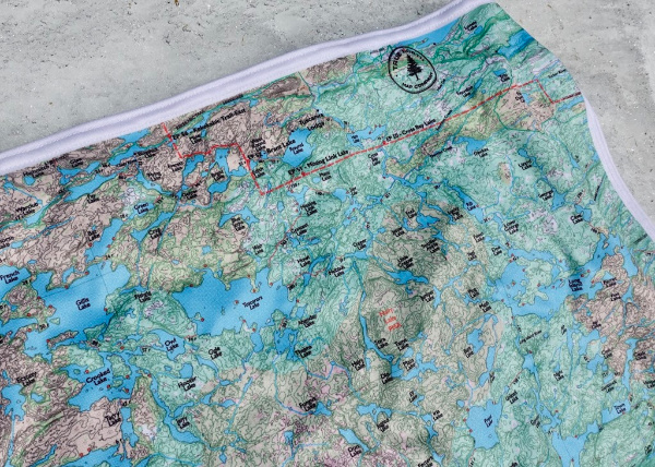
The tan background indicates areas affected by wildfire, while the green background shows old growth forest
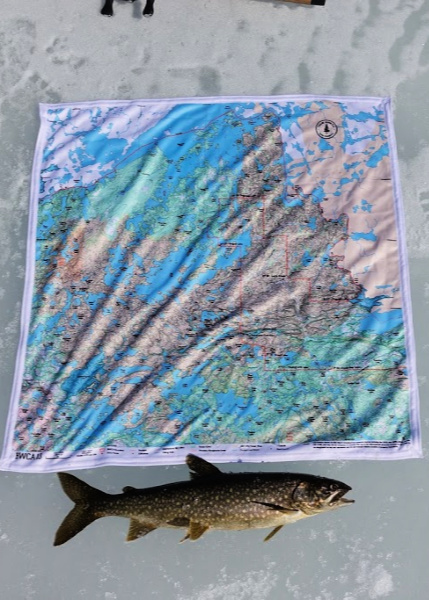
We got our first shipment of True North Maps a few weeks back. We were intrigued by the concept of the maps, but wanted to test out their functionality. Since then, the maps have accompanied us on many a Boundary Waters ice fishing trip (see #7daysoficefishing over on Instagram) and we’ve even thrown one in the wash. (More on that later . . . . )
If you’re asking yourself, do we really need another company making Boundary Waters map, the answer is no, we don’t really need another company printing BWCA maps on paper. Happily, True North Map Company isn’t printing their maps on paper. What sets them apart from every other Boundary Waters map company is that their maps are printed on microfiber fabric – think the kind of material that your Buff is made out of. This means you can literally tie these maps in knot, in a bow, throw them over your shoulder, or wear them as a bandana.
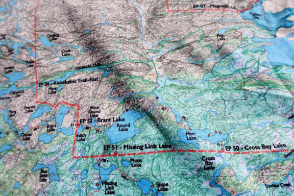
We kind of wondered how clear a map printed on fabric could be, but were pleasantly surprised by how clearly the lakes “pop.” The True North maps cover all the things you’d expect from a Boundary Waters map: lake and island names, campsite locations, portages with the distance in rods, campsites, and of course the actual Boundary Waters boundary. With a scale of 1 mile = 1.5,” the scale is the same as on Fisher maps, although the True North maps don’t have as much lake depth detail. They do however offer detailed topography and use color grading to show forest fire areas.
From a navigation standpoint, where True North maps really shine are as a secondary map for the “non-navigator” in the canoe. It’s always nice to have as many people as possible on the trip aware of your position on the map to increase your chances of remaining “found.”
I also think this is an excellent map option for a route you’re already familiar enough with that you don’t require notation on the map. With a True North map, you can just ball it up in your pocket and pull it out whenever you want to verify you’re on the right course. Maybe it’s just me, but when I go on a Boundary Waters day trip, I always find it a little annoying to have to carry a single map over the portages, since the map case is usually too big to easily stuff into my daypack. But as Dave Seaton down at Hungry Jack Outfitters is fond of saying, “If you don’t have a map, you’re lost; you just don’t know it yet,” so traveling without a map really isn’t an option, no matter how well you know a route. With a True North Map, I can just tie the map around my leg or to the canoe and enjoy hands-free portaging.
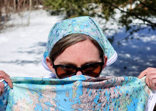
Made of UPF 50 microfiber fabric, True North maps can be used for sun protection . . . or any of your Boundary Waters banditry needs.
Personally, the thing we’ve enjoyed most about these maps isn’t their navigational function, it’s been having a microfiber cloth close at hand. We’ve grabbed them many a time to dry our hands after catching a lake trout or to wipe water off the fish finder screen. The maps are machine washable, and I can verify that they come out of the washing machine just as bright as they went in (and in my case, decidedly less fishy smelling). Be sure to line dry them so they stay nice and soft.
As a canoe outfitter, one of things we’ve really enjoyed about working with True North Maps is how customizable the maps are. We’ve worked together to move a portage location to improve the maps’ accuracy. They even cut a custom map for us (the BWCA TL) that specifically shows the areas you’ll travel through with #50 Cross Bay, #51 Missing Link Lake, or #52 Brant Lake entry point permits. The custom map also shows Tuscarora Lodge and Canoe Outfitters’ location. We’ll be stocking those in our gift shop this season, along with their BWCA 13 map, which covers Seagull and Saganaga Lakes and the entire Granite River.
The BWCA TL map goes as far west as Little Saganaga and Gabimichigami, shows the entire Frost River Loop, and goes as far south as Sawbill.